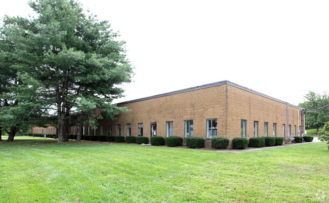
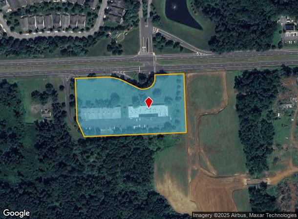
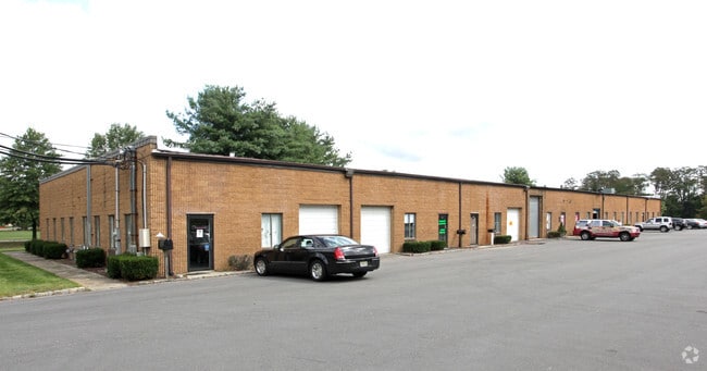
Property Record
227 Highway 33, Manalapan, NJ 07726
NEARBY LISTINGS FOR SALE OR LEASE
Property Detail
227 Highway 33
New York-Jersey City-White Plains, NY-NJ
PATRIOT PARK
28-00078-0000-00012-04
Monmouth
Warehouse
New Jersey
X
12.4
34025C0140F
5.17 AC
2024
Western Monmouth
2025
Northern New Jersey
808800
DEMOGRAPHICS near 227 Highway 33
1 Mile
3 Mile
5 Mile
2024 Total Population
3,270
20,348
72,250
2029 Population
3,230
20,099
71,488
Pop Growth 2024-2029
(1.22%)
(1.22%)
(1.05%)
Average Age
45
43
41
2024 Total Households
1,176
7,555
24,609
HH Growth 2024-2029
(1.45%)
(1.43%)
(1.23%)
Median Household Inc
$159,962
$136,739
$128,353
Avg Household Size
2.70
2.60
2.80
2024 Avg HH Vehicles
2.00
2.00
2.00
Median Home Value
$617,164
$546,216
$539,353
Median Year Built
2001
1992
1983
Nearby Places
Map Layers
Map Styles
 Street
 Aerial
- Restaurants
- Banks
- Shops
- Fitness
- Groceries
PUBLIC TRANSPORTATION
AIRPORT
Trenton Mercer
DRIVE
WALK
Distance
Trenton Mercer
47 min
29.9 mi
Newark Liberty International
DRIVE
WALK
Distance
Newark Liberty International
56 min
43.8 mi
Freight Ports
New York Container Terminal
DRIVE
WALK
Distance
New York Container Terminal
49 min
36.0 mi
SALE & LEASE HISTORY
LISTING DATE
SALE/LEASE

Sep 28, 2024
For Lease
Dec 07, 2021
For Lease
Apr 13, 2023
For Lease
Nearby Properties
Address
Land Use
TOTAL SIZE
Lot Size
Zoning
Address
Land Use
TOTAL SIZE
Lot Size
Zoning
825,686 SF
151.47 AC
575
Address
Land Use
TOTAL SIZE
Lot Size
Zoning
52.16 AC
H-1
Address
Land Use
TOTAL SIZE
Lot Size
Zoning
3,060 SF
114.66 AC
PCD
Address
Land Use
TOTAL SIZE
Lot Size
Zoning
67.30 AC
PB
Address
Land Use
TOTAL SIZE
Lot Size
Zoning
285,037 SF
40.82 AC
H-1
Address
Land Use
TOTAL SIZE
Lot Size
Zoning
246,459 SF
60.38 AC
ROL
Address
Land Use
TOTAL SIZE
Lot Size
Zoning
13,730 SF
19.29 AC
CM-3
Address
Land Use
TOTAL SIZE
Lot Size
Zoning
220,000 SF
25.42 AC
PCD
Address
Land Use
TOTAL SIZE
Lot Size
Zoning
176,661 SF
13.04 AC
OB01
Address
Land Use
TOTAL SIZE
Lot Size
Zoning
138.38 AC
R-E
Address
Land Use
TOTAL SIZE
Lot Size
Zoning
23,260 SF
17.90 AC
B-10
Address
Land Use
TOTAL SIZE
Lot Size
Zoning
23.08 AC
PB
Address
Land Use
TOTAL SIZE
Lot Size
Zoning
12.15 AC
P-1
Address
Land Use
TOTAL SIZE
Lot Size
Zoning
13.21 AC
OB01
Address
Land Use
TOTAL SIZE
Lot Size
Zoning
88,303 SF
39.55 AC
R-40
Address
Land Use
TOTAL SIZE
Lot Size
Zoning
79.20 AC
R-E
Address
Land Use
TOTAL SIZE
Lot Size
Zoning
134,958 SF
58.12 AC
R-40
Address
Land Use
TOTAL SIZE
Lot Size
Zoning
1,980 SF
22.35 AC
Address
Land Use
TOTAL SIZE
Lot Size
Zoning
244,275 SF
2.50 AC
RM-1
Address
Land Use
TOTAL SIZE
Lot Size
Zoning
60,003 SF
7.55 AC
H-1
Address
Land Use
TOTAL SIZE
Lot Size
Zoning
10.25 AC
PB
Address
Land Use
TOTAL SIZE
Lot Size
Zoning
56.30 AC
Address
Land Use
TOTAL SIZE
Lot Size
Zoning
2,322 SF
44.35 AC
R-E
Address
Land Use
TOTAL SIZE
Lot Size
Zoning
54,690 SF
3 AC
H-1
Address
Land Use
TOTAL SIZE
Lot Size
Zoning
149,292 SF
9.56 AC
RM-1
Address
Land Use
TOTAL SIZE
Lot Size
Zoning
164,229 SF
10.83 AC
RM-1
Address
Land Use
TOTAL SIZE
Lot Size
Zoning
7.87 AC
SEDA
Address
Land Use
TOTAL SIZE
Lot Size
Zoning
6.66 AC
CDFS
Address
Land Use
TOTAL SIZE
Lot Size
Zoning
20,203 SF
1.70 AC
H-1
Address
Land Use
TOTAL SIZE
Lot Size
Zoning
9.63 AC
SED2W
The World's #1 Commercial Real Estate Marketplace
Connect with us
© 2025 CoStar Group
The information above has been obtained from sources believed reliable. While we do not doubt its accuracy we have not verified it and make no guarantee, warranty or representation about it. It is your responsibility to independently confirm its accuracy and completeness. Any projections, opinions, assumptions, or estimates used are for example only and do not represent the current or future performance of the property. The value of this transaction to you depends on tax and other factors which should be evaluated by your tax, financial, and legal advisors. You and your advisors should conduct a careful, independent investigation of the property to determine to your satisfaction the suitability of the property for your needs.